
Hound Tor, Dartmoor. Image via Historic England.
Imagine exploring a deserted medieval village. You wander down an ancient hollow way, pass a deserted fishpond, and step into an abandoned house. Inside, you find all sorts of clues about medieval village life. But where, oh where, did everyone go?
There are lost, deserted and shrunken medieval villages scattered all over Britain, and each one has its own unique story to tell. Many were abandoned in the 14th and 15th centuries when landlords emptied the villages to make way for more profitable sheep rearing, but there are plenty of other reasons too.
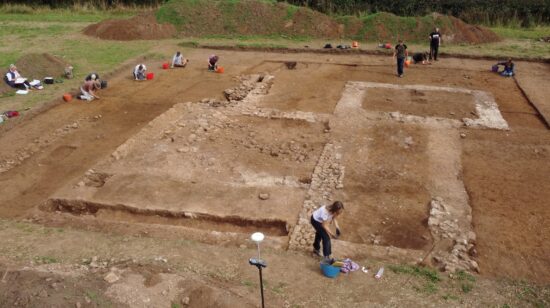
In August, we’ll be resuming our crowdfunded excavation at Elmswell, East Yorkshire, where the remains of a medieval village lie alongside a Roman ladder settlement and some Anglo-Saxon buildings too. While archaeologists have already learned lots from excavating medieval villages, we think this one has the potential to become one of Yorkshire’s most important multi-period sites. You can sign up to join the dig or follow it online right here.
As if you need any more convincing that digging up a long-lost medieval village would be downright awesome thing to do, here’s a few we think might just persuade you…
The one that was destroyed by outraged locals
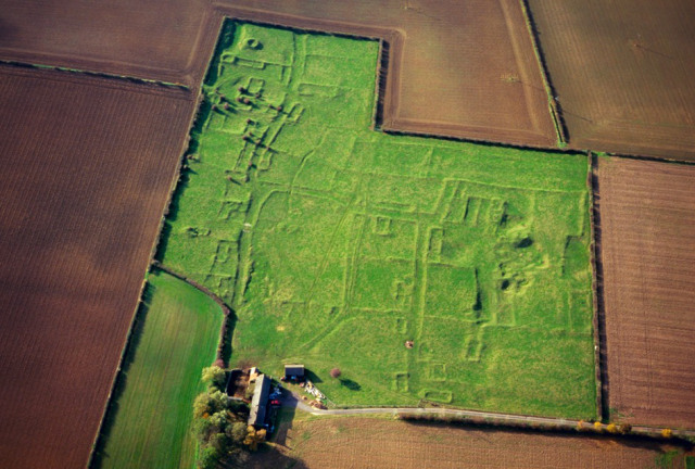
Gainsthorpe, image via English Heritage
Gainsthorpe (Lincolnshire) is one of the best-preserved medieval villages around, and its footprint is still clearly visible as a series of linear humps and bumps. Ancient streets survive as worn ‘hollow ways’, and on either side there are individual houses separated by low banks, with ‘tofts’ – frontage plots that once contained buildings and sunken yards – and garden ‘crofts’ stretching behind. According to legend, it had become a den of thieves, and was demolished by unhappy locals. The truth of this remains unknown, and it may have simply suffered the fate of other nearby villages which were subject to plague, soil erosion, sand blowing, and deliberate depopulation. In the words of the 17th century antiquary Abraham de la Pryme, “I fancy the town was eaten up with time, poverty and pasturage“.
The one where landlords put profits before people

Rand Medieval Village, via Bing Maps
Rand (Lincolnshire) is a classic, and heartbreaking, example of a medieval village that grew rapidly, until its landlords decided to boot out the villagers in the 1500s to make way for more profitable sheep farming. Detailed archaeological work has revealed the village’s principal street, along which the village expanded in the late 12th or 13th century. You can see plots for houses on both sides of the street, with platforms representing front yards. There’s a second hollow way, also with houses, which represents a later period of expansion, and an area of ridge and furrow cultivation to the north, which is all that’s left of the open fields that surrounded the village.
The one where people believed in the living dead

Wharram Percy, image via Historic England
Wharram Percy (North Yorkshire) is just 15 miles from Elmswell. It has been investigated by archaeologists for over 60 years, and is undoubtedly Britain’s most famous deserted medieval village. Like Rand, village life came to an end in the 1500s when the landowners forcibly evicted the villagers and destroyed their homes to make way for more profitable sheep farming. You can still walk among the ruins of its church, manor houses and 40 peasant houses today. Among them, archaeologists have found invaluable evidence of village life, including some remarkable signs of belief in the living dead.
The one that was abandoned by its young people

Newtown, Isle of Wight. Image via Bing Maps.
While villages tended to spring up somewhat organically, medieval new towns were much more planned. Newtown (Isle of Wight) is an example of one that failed economically, thereby leaving its original medieval layout largely intact. Despite a promising start, it all came to an end when the French attacked in 1377. Bizarrely, it is said that when the French landed, they found there were only middle aged men left to defend it, and stories of a Pied Piper who spirited away an entire generation of children when the townspeople refused to pay the money they’d promised him.
The one that was ruined by climate change

Hound Tor. Image via HIstoric England.
Walk out to Hounds Tor (Dartmoor) and you’ll be able to retrace the steps of its medieval inhabitants. The village, which was excavated in the 1960s, includes a cluster of 13th century Dartmoor longhouses, barns, a small lean-to, corn drying ovens and a kiln. But archaeological evidence shows that sadly it wasn’t inhabited for long. Population growth and favourable weather had encouraged people to move higher up on to the moor, taking in marginal land that was normally too difficult to cultivate. Pollen evidence suggests that cereal farming had ceased by 1350, while the corn dryers in the grain storage barns suggest the inhabitants struggled with a rapidly deteriorating climate.
The one that was flattened to make way for a very posh garden

Kirby. Image via Historic England.
The ruins of Kirby (Northamptonshire) sit in the grounds of an estate, but you can clearly see the outline of some crofts, tofts and a buried fish pond. The village was always pretty small, and was finally dissolved around 1600 to make place for a formal Jacobean Garden. Clearly, the landowners didn’t want any unsightly peasants ruining the view!
The one that’s now under the sea

Dunwich, as seen from under the sea! Image via University of Southampton.
Today, Dunwich (East Anglia) is almost entirely submerged below the North Sea. On the plus side, that makes it Europe’s largest underwater medieval site! Once upon a time, however, it was a thriving port that rivaled London. But then it was battered by a series of powerful storms in the 13th and 14th centuries. With its harbour silting up, a failing market, and the town partly destroyed, and some violent disputes with piratical monks, the storms quite literally tipped it over the edge and many people simply gave up on Dunwich. When archaeologists explored the underwater ruins, they found the ruins of four churches, a toll-house, several shipwrecks and new evidence of the port that was once the capital Anglo-Saxon East Anglia.
The one that’s still to be discovered…

Elmswell. Image via Bing Maps.
Elmswell (East Riding of Yorkshire) is not only the site of a medieval village, there’s plenty of evidence of Iron Age, Roman and Anglo-Saxon settlement too. The as yet unexplored medieval village has been photographed from the air, and there’s a large field system of Iron Age-Roman date visible as crop marks. There’s also plenty of signs of a well-ordered medieval village, including well-established hollow ways, flanked by crofts, tofts and buildings. How much more survives? And why was it abandoned? Well, that’s where YOU can help!
Want to try archaeology?
DigVentures runs archaeological digs that you can be part of. Join us on site and we'll teach you everything you need to know to be an archaeologist for the day.
Find out more
Written by Maiya Pina-Dacier
Director of Engagement at DigVentures, Maiya digs with a trowel in one hand, and a Twitter feed in the other. She loves finding new ways to get people involved in archaeology - online and in the field.




Comments (14)
I know where possibly a Roman village/town was,its on a farm but the farmer does not want anyone to know about it,he just wants to get on with farming it and he his not interested in history!
How exciting! I’d love to go on a dig with you, someday 🙂
Very interesting to read particularly about Dunwich. I’m writing about another village now under the sea, situated a few miles out now from Cromer in Norfolk and mentioned in the Doomsday book: Shipden, spelt a couple of different ways. Do you know of any aerial views of this area?
I’d love to go on a dig. I’ve have my gcse in archeology. Would love to help. It’s on my bucket list.
Could we please also look in southwest Scotland for medieval villages populated by the Britons of the Old North? Say in the Strathclyde region and/or the western Souhern Uplands. Bone for DNA genetics, esp. Y-DNA would ideal.
Many Thanks!
Brian McMichael
R1b>L21>DF49>DF23>ZP148>ZP179
So excited to be coming to Elmswell later this year!
So many of the deserted villages are nameless, which is frustrating for me, because scholarship suggests that my surname (Rapsey) is locational and I would very much like to know from where. I’ve found a farm on the border of Devon and Cornwall; I know of a house in Sussex, and Wrabb’s Head in Essex could be it, with a silent W and allowing that “b” and “p” sound similar. Also the “rap” is a small coin in a dialect of German and “sey” is an island or piece of high ground surrounded by marsh. Sorry,folks,this is a bit off-message but it is germane, and any ideas would be welcomed!
The Domesday Book may shed some light on it, If it was a village deserted in the medieval period, there is a strong chance it was thriving in 1086
A house backyard is a particular place. Attain out!
Ideas?
I’ve never read that the “enclosures” which were prompted by sheep farming started in the 14th century (1300s). As far as I recall, they started in the 15th century (specifically, the late 1400s).
We have one in Sheriff Hutton – the lost village of East Lilling, a clearance by the Nevilles to improve the view from the castle, with the new West Lilling on the west side of the Deer Park of Sheriff Hutton Hall. Researched by University of Leeds in the 1950s.
What about this one? Abbotston. https://goo.gl/maps/77Ve9fmpiV1JP9rd9
https://historicengland.org.uk/…/the…/list-entry/1001866
I thought it was well known it was done as land clearance for the production of sheep.