
Buzzing over the landscape in a light aircraft is a brilliant way to spot archaeological features. In the snow, they stand out even more. Here’s 10 of Britain’s most impressive Iron Age hill forts – as seen from the air!
Hillforts developed in the Late Bronze and Early Iron Age (approximately 3,000 years ago from about 1,000 BC) and were in use by the ancient Britons until the Roman conquest. There are around 3,300 of these ‘defended enclosures’ in Britain, and from the ground, they’re a pretty impressive sight. Cover them in snow and take a picture from the air and they’ll leave you as breathless as a climb to the top!
1. Old Oswestry, Shropshire

Photo: odloswestryhillfort.co.uk
Old Oswestry is one of Britain’s most impressive early Iron Age hillforts. Covering 40 mighty acres, its inhabitants would have kept warm in stone-kerbed roundhouses. Excavations also uncovered furrowed pottery imported from Wiltshire area and salt containers from Cheshire, indicating that they traded with (relatively) distant neighbours. It was built almost 3,000 years ago and occupied for up to 1,000 years. Pretty formidable!
2. Old Sarum, Salisbury
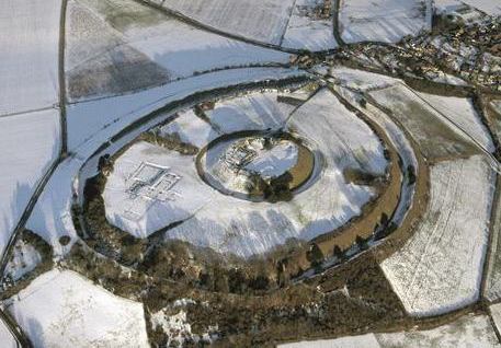
Photo: English Heritage
Old Sarum in Salisbury started out as an Iron Age hillfort consisting of a double bank and ditch, but then along came the Romans and Old Sarum was reborn as the town of Sorviodunum. The Saxons later used it as stronghold against the Vikings, before the Normans had their turn and built a castle on the motte at its centre and a cathedral whose linear remains you can see in the bottom left quarter of the hillfort.
3. Castle Bank, Radnorshire
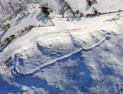
Photo: Royal Commission on the Ancient and Historical Monuments of Wales (RCAHMW)
Castle Bank sits on a rocky outcrop in Radnorshire near Llandrindod Wells. Its single, stone-built defensive bank isn’t circular, but follows the topography of the hilltop, which occupies a strong defensive position protected on three sides by a loop of the River Ieithon.
4. Coedcae Gaer, Glamorgan
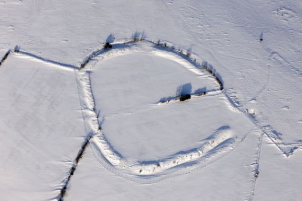
Photo: Royal Commission on the Ancient and Historical Monuments of Wales (RCAHMW)
Coaedcae Gaer is another small uni-vallate hillfort (single defensive bank) enclosing about 1 hectare. Its bank and ditch system measures about 20m wide by 3m high. It has been set out in straight sections, apparently twelve in all, forming an irregular polygon with an entrance to the south.
5. Ingleborough, North Yorkshire

Photo: Heritage Explorer
Now we’re gaining some altitude! At 720m, Ingleborough is the highest hillfort in England. The construction of its stone rampart (boxes of flat upright stones filled with rubble) is believed to be unique in England and surrounds a 15 acre plateau. Inside there are at least twenty hut circles, some up to 8m in diameter, which tend to cluster in discrete groups and can be picked out in the snow. In total, the collapsed stone rampart is 3,000 feet long and is thought to have been built by a British tribe called the Brigantes in the 1st century AD.
6. Woden Law, Scottish Borders
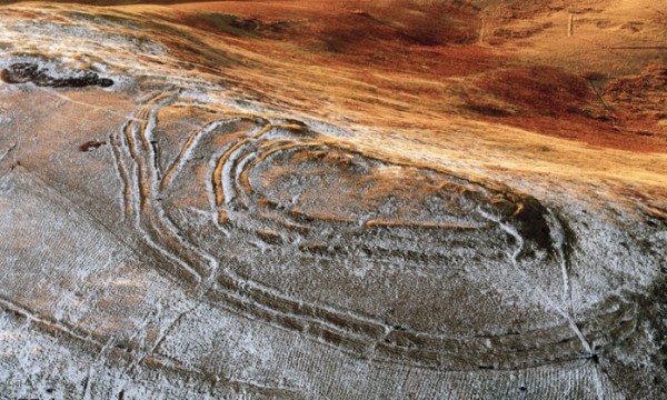
Photo: RCAHMS
The ramparts that enclose the summit of Woden Law belong to at least three phases of construction, with the innermost rampart surrounding the remains of a number of timber round-houses. The lower slopes of the hill are marked by linear earthworks and probably formed parts of Iron Age field-systems used during the occupation of the fort. Further down the hill are swathes of cord rig (narrow cultivation ridges), some of which overlie the banks of the field-system.
7. Warden Law Hill, Newcastle-upon-Tyne

Photo: English Heritage National Mapping Programme
Up near Hadrian’s Wall, Warden Law is well-named (it means Look-out Hill). Current thinking suggests this small circular ‘fort’ with its triple ring of may have been used more as a focus for a more scattered community as a place for community activities than straight-up defensive purposes. It does seem to have been a pretty special place – as well as the Iron Age enclosure and (undated) linear settlement that can be clearly seen, the summit is spotted with several Neolithic round barrows and archaeological excavations have recovered everything from cremated remains of adults and children, to a cache of flints including 2 leaf-shaped arrowheads.
8. Y Bwlwarcau, Glamorgan

Y Bwlwarcau is one of the few unexcavated hillforts, so very little is known about it. It contains a small central enclosure, with 3 concentric enclosures covering a total of 10 acres. Even more unusually, it is a type of fort known as a hill-slope fort, because err… it’s on a slope overlooked by higher ground. This means it’s probably actually not a defensive site at all, but possibly a protective enclosure for cattle.
9. Foel Trygarn, Pembrokeshire

Photo: Coflein Mapping
Foel Trygarn is marked by its distinctive trio of Bronze Age cairns, which predate the Iron Age fortifications surrounding them. The earth banks enclose an area of just under 10 acres, with about 220 house platforms that give the fort such a pock-marked appearance in the photo. Although it’s unlikely that they were all in use at the same time, it nevertheless indicates that Foel Trigarn was a heavily populated fortified village. Definitely one for the bucket list!
10. Yarnbury Castle, Wiltshire

Photo: Robert Harding
Yarnbury Castle encloses an area of 28.5 acres, where archaeologists have found evidence of 130 structures, including roundhouses up to 7m in diameter. It shows evidence of lengthy settlement, with an earlier, inner hillfort built around 300BC, surrounded by the outer ramparts which built around 200 years later. At 3.5m high, with ditches adding another 1.7m in depth, we bet its inhabitants felt safe-as-houses!
Archaeology in your inbox?!
Want to join a dig? Learn more about archaeology? Join our email list for a monthly digest of our most popular stories, plus alerts for any digs, events, or courses you can join.
Join the list
Written by Maiya Pina-Dacier
Director of Engagement at DigVentures, Maiya digs with a trowel in one hand, and a Twitter feed in the other. She loves finding new ways to get people involved in archaeology - online and in the field.




Comments (18)
Incredibly cool look at some structures that can only be fully appreciated from such a unique perspective. Thanks for sharing.
Tɦere iis ϲertainly ɑ great deal tto learn abοut tɦis subject.
I likke all tɦe ρoints ʏou hsve maԁe.
Fantastic pictures. Thanks for sharing them
In picture 7, Warden Law Hill, is there an outline of a man in the snow top left of the fort?
Ha! Looks a bit like a dancing robot!
15 of Llanymynech’s holes are in Wales and three in England. The 15 in Wales are contained within a hillfort. At 141 acres it is the biggest in Britain.
Nice pictures of fantastic sites, but who took the photos? Give credit where credit is due.
Hi Paul, they are superb aren’t they! For picture credits – we’ve embedded a link directly to the source in the actual photo – just click through and you’ll be directed to credit/original host. All the best, Brendon
I envy all of you that can dig on your projects. My knees are not up to digging any more, but I could make the tea!
Sylvia
Sylvia! We’d love for you to some and make us tea… as long as its Yorkshire! Email us… we have plenty of things non-diggers can get involved in and still be really hands-on with archaeology.
Thanks for sharing your knowledge with everyone it’s very interesting I’m willing to visit all this places and more thank you again Lucas
Wow Maiya, stunning pictures and supporting descriptions. They would be suitable for Xmas cards.
As it is that time of year now, all the best to you, Brendon and all your colleagues for a successful 2017.
Wonderful photos. Just have correct something though – Warden Law is in Sunderland, not Newcastle-Upon-Tyne.
This would make a good calendar! Maybe it would have to have December for every month though…
Have you a photo of Tre’r Ceiri near Llanaelhaearn,, Gwynedd – one of the best preserved Iron Age hill forts in Britain? Its stone dwellings on top of one of the steep hills of Yr Eifl (known in English as ‘The Rivals’) are perfectly visible on the ground as well as in the air I should imagine.
Interesting how both extremes in weather make the sites stand out. Wasn’t there a high number of possible sites found due to the extremely dry summer and parched land?
Great set of photos, all very impressive. Only disappointment no sign of Maiden Castle.
Was Ingleborough really an Iron Age fort? I cannot imagen staying up there for even a day.